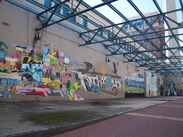
Discovery of more artiness down an alleyway & sidestreet or two.
I do like Shockoe Bottom. It's roughly half an hour's walk from Downtown so exists in its own bubble of neighbourhood. I like the memories it holds from July & our visit. The vibe of the place from the murals, the market & the cafes.
I like how here road, rail, canal and river all meet together & intersect. Noise of the trains passing through. Traffic overhead, river to the left.
It's easy from that to grasp just how significant Shockoe Bottom used to be - the bustling ports & the tobacco factories which once made it such a hive of industry.
Following our walk, Sarah lent me two books: a coffee-table tome "Richmond's Fan District" - my current book-over-breakfast of a morning.
It's filling me in on Richmond's early days - so far I've read of William Byrd I through to Byrd III, land lottery sales in England & "Scuffletown". The second is "Maritime Richmond" - with its recognisable sepia-tinted cover of the 'Images of' series.
(Sarah also let me in on the insight that the Dairy, despite its fancy exterior, is also - somewhat logically - a real pain to furnish. They had an actress live there a while & what with all the curvy walls, IKEA just isn't kitted out to accommodate such things. ;) Likewise hanging picture frames. You'd have to be really inventive to get round that! Pun intended.)
From the former then, I bring you this insight:
"In 1790, most Richmonders still lived in an area extending for a number of blocks east & a few blocs west of Shockoe Creek, near which stood the public market, warehouses, taverns, shops, lumberyards, stables & other business establishments."Shockoe Bottom's fallen into some disrepair over the years. Empty warehouses. Lettering on the buildings fading away from proudly declaring what they once housed. But the nineties also brought revival to the area and, much like the waterways of Britain, it's currently up-and-coming again with restaurants and loft apartments being built close to the water. I find it all rather fascinating.
 |
| Modern-day re-invention on East Cary Street. Its art deco font makes me think of Paris & the Metro. |
We found ourselves by Bottoms Up pizza place at the beginning of Richmond's Canal Walk, just by the floodwall gates. (I looked for an online route map but to no avail. Ah, there we go. DIY, starting from point A - you can see how the canal runs parallel to the Downtown Expressway.)
Richmond's Canal Walk meanders 1.25 miles through downtown Richmond along the banks of the Haxall Canal & the James River & Kanawha Canal.With the recent visit from Superstorm Sandy (note the re-naming post-event, wreaking havoc on some people's insurance policies as they seek to reclaim for hurricane damages), there had been some talk of the floodwall at work.
The Canal Walk presents four centuries of Richmond’s history interpreted through medallions, monuments & exhibits along the Canal Walk &
Brown’s Island.
It's rare for Richmonders to close the gates on the James. When it does happen, it strikes up much public interest with locals coming down to watch. I guess it's a bit like the 5-Rise lock watches. Sarah told me they were closed once in recent years (either 2003's melting snow or tropical storm Gaston in 2004) out of protection for the city but ended up inadvertently causing more damage.
 Facts & Figures!
 - Total cost for building the floodwall: $143 million.Floods which have made it over (as marked by the plaques):
- Total floodwall length: 3.2 miles of concrete, steel, earth & rock.
- Combined damages from the major floods (1969 - 1987)
which prompted its building: $140 million.
- Designed to protect Richmond from floods of up to 32 feet.
Tropical Storm Agnes: 36.5 feet in June 23, 1972
Flooding at 30.8 feet on Nov. 7, 1985
Tropical Storm Camille: 28.6 feet on Aug. 22, 1969
I did like the feeling of being on the outside, looking in as we crossed through the gates to stand on the other side of the 'wall. Outer city limits. They've sculpted the area & added in a trail so it works for both the riverside workers & walkers alike.
Introducing Henry "Box" Brown:
 |
| THIS STRUCTURE IS A PIECE OF PUBLIC ART *&* A PLAYGROUND. |
The sculpture itself is a perfect cross between public art & interactive history - covered with phrases from Brown, providing a concise history as well as a to-scale perspective of Brown's journey. (The photo was taken from afar is because a wee girl was playing in & around the box & I didn't want her to be discouraged from her game or interaction with the sculpture.)
We continued our walk, arriving at the Tidewater Connection Locks (the bit on the map where the canal divides), turning right to find ourselves at the floodwall/power plant murals - where Megan had taken M. & I back in July. Still there, still as fabulous as ever. (Not so sure about the chair 'art' : )
So in context to my aforementioned photos from before:


No comments:
Post a Comment